Geology and Whisky on Islay
Few weeks ago, I visited the Queen of the Hebrides, or better known as the isle of Islay. My dad and I organised the trip for some friends of ours with the main objective to show them the many beauties of the island. Two years ago my dad and I made a ‘reconnaissance’ trip to explore those beauties.
 |
| Machir Bay viewed from the old abandon RAF radio station. Photo credit: Maurits Kok. |
Being true to my blog, which is a more scientific-orientated blog, I will not make this post a travellers log, but lets just say we visited several distilleries (even one that is now under construction), enjoyed the cuisine (which was quite high standards in the hotel we stayed), and made many long walks through the fantastic and overwhelming landscapes of the Scottish island. This island keeps surprising me with its fascinating history, incredible geology, and beautiful whiskies.
 |
| Whisky Wharehouse tasting at Bruichladdich. Photo credit: Maurits Kok |
Before the trip I bought a book about the “A Guide to the Geology of Islay”, which described the whole geological history, going back 1.8 billion years to evidence of the Last Glacial Maximum (last ice age), ‘only’ 25,000 years ago. A short description can be found on this website. Me, becoming more and more a geoscientist, wanted to explore and see some of this evidence. So, at the second evening of our trip, when the group went to one of Port Ellen’s finest pubs, I decided to make a short geological field trip to observe a meters thick Cenozoic Dolerite Dike in the Precambrian metabasite sills and Port Ellen Phyllite that now make Port Ellen’s terrain. Sounds quite geological to me, right?
 |
| The Dolerite Dyke location sketched in red on top of a satellite image of the Port Ellen bay. |
The dyke in question looks like a jetty from the satellite image, but up close they are black rocks eroded by the constant washing of the bay’s waves. They have a completely different appearances than the rocks I past by on the little beach, when I was walking towards the ‘black jetty’. Those rocks were finely layered, illustrating the deposits that slowly build up the terrain I was walking on now. No, these black rocks were not layered, but emanated volcanism; big, tough rocks, smoothed by the ocean, crumbled and covered by green algae. The outcrop started a few meters into the water of the bay and was following the NW-SE direction inland. It quickly dived beneath the surface under a row of little cottages. I wanted to see if the dyke would outcrop somewhere else behind the houses.
 |
| The Dolerite Dyke in the bay of Port Ellen. The main street of Port Ellen is visible on the other side of the bay with one of its finest pub. |
So, my hike through the dunes began, observing many evidence of the sedimentary nature of the surrounding terrain. Layers, upon layers, upon layers of sand deposits, sometimes cut through by little quartz dykes. Also, the Port Ellen fishermen had constructed little sheds for them to watch the sea and hope for calm weather. In the little natural harbours between the rocks, small improvised concrete docks were constructed with little fisher boats in various states of decay were scattered around the dunes. Still, eager to explore the rocks in hoping to find outcrops of the Port Ellen dyke, I endured the growing wind, now having full effect, because I was not anymore in the shelter of the island’s cottages. The smell of rotting seaweed was execrable every time I found some shelter behind a rock formation, then blown away by the wind every time I would cross a gab in the rock formation.
After an hour of climbing the rocks, I found the expected location of the dyke, but it was used as fundament for a sewer pipe of the village. Lots of concrete was pouted to facilitated the rusted pipe, so no change of inspecting any natural rock formations. I decided to walk seaward, against the direction of the now-grown-in-size wind. At the coastline I saw a spectacular view of the ocean, a battle between the winds and the ocean water. If the weather would have been clear, I could see Ireland, but the view I saw was white-topped waves and dark skies. One very brave fisher-boat was hoping to catch some fish, but seeing the exhaust fumes coming out the exhaust pipe, suggested that the diesel motor was working in overdrive. A constant howling of the wind…
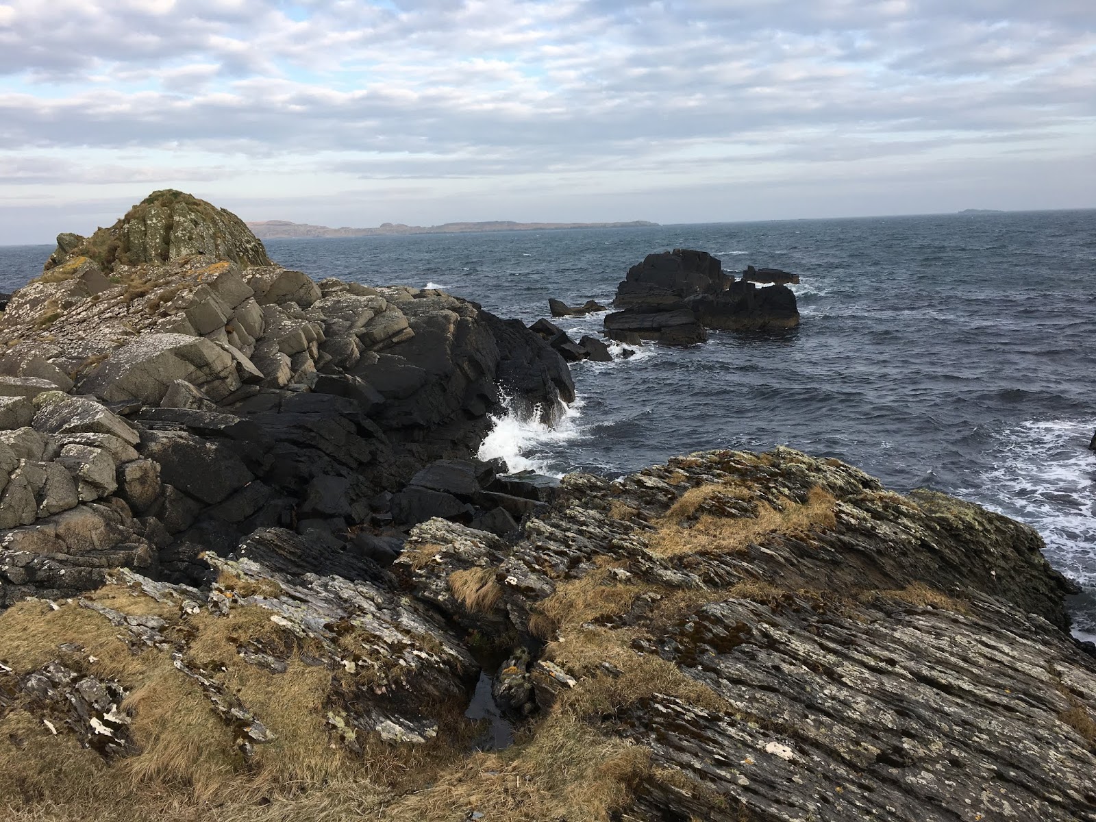 |
| The other end of the Dolerite Dyke. In the back, the little isle Texa can be viewed. The dyke is easily found, because of the lack of layering on the rock structure. |
There I found the outcrop of the dyke leaping into the ocean as the black snake it was. A clear distinction between the structure of the layered and the volcanic rock was visible. On one side, the ocean had carved out the boundary between the two rocks and made a small pebble beach for me to examine the two different rock sides.
 |
| The ocean had formed a little pebble-beach between the two distinct rocks. Left layered rock and right the Dolerite Dyke. |
The dyke had a similar width as in the calm bay of Port Ellen and the appearance of the rock was the same. The other side of the dyke showed some more detailed structures of the volcanic intrusion. A small dyke perpendicular to the main dyke direction was intruded between the layered rock, possible through an old fault, pushing away the layering of the rock terrain.
 |
| This little finger of the main dyke was situated perpendicular to the main dyke formation (NW-SE). |
This dyke was a result of the opening of the North Atlantic Ocean just 60 million years ago, I read in the little booklet about the geology of Islay. Due to this opening of the ocean I was now seeing in battle with the wind, the incredible rock formation I was standing on was created, maybe seen and appreciate by a hand-full of people. The high energy buildup of the event had pushed hard solid layered rock several meters apart, all happening in the deep depths of the solid Earth. Many centuries had eroded the surface, such that I could now be whiteness to this magnificent rock formation. That evening the whisky tasted just that much more comprehensive.
 |
| The Lagavullin distillery. Photo credit: Maurits Kok |
List of distilleries we visited:
- Bruichladdich: Warehouse tasting (very nice Port Charlotte)
- Kilchoman: Distillery Tour (the Loch Gorm stays my favourite)
- Bunnahabhain: Premium tasting plus Tour (Toiteach!!! pronounced toy-chuck)
- Coal Ila: Distillery Tour (12 years old as usual)
- Laphroaig: Distillery Tour (Laphroig Lore was a surprise, new barrels!?!)
- Lagavullin: Core Range Tasting Tour (16 year old was still the best)
The summary of the trip to the island of Islay with music (credit video: Kjartan Majdandzic)!


A visual indication of the trip can be found here:
BeantwoordenVerwijderenhttps://vimeo.com/271559572 or https://www.youtube.com/watch?v=W29YBcNaS1o
Video credit: Kjartan Majdandzic